
Vaizdas:Positions of ancient continents, 550 million years ago.jpg
Šios peržiūros dydis: 600 × 600 taškų. Kitos 3 rezoliucijos: 240 × 240 taškų | 480 × 480 taškų | 820 × 820 taškų.
Didesnės raiškos iliustracija (820 × 820 taškų, rinkmenos dydis: 426 KiB, MIME tipas: image/jpeg)
| Ši byla yra iš bendros Wikimedia Commons nemokamų resursų duomenų bazės, palaikomos Wikimedia Foundation organizacijos. Norėdami sužinoti licencijavimo smulkmenas, žiūrėkite paveikslėlio aprašymą |  |
Į paveikslėlio aprašymą |

|
Šis paveikslėlis geology (arba visos šio straipsnio iliustracijos) turėtų būti iš naujo sukurtas naudojant vektorinę grafiką, kaip, pavyzdžiui, SVG failas. To privalumus ir daugiau informacijos rasite straipsnyje Commons:Media for cleanup. Jei šio failo SVG versija jau sukurta, prašome ją įkelti. Po įkėlimo šios iliustracijos puslapyje pakeiskite šį šabloną į {{vector version available|naujas paveikslėlio pavadinimas.svg}}.
|


|
This map has been uploaded by Electionworld from en.wikipedia.org to enable the |
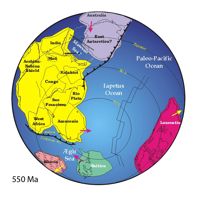
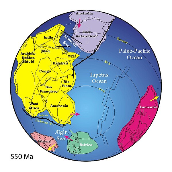
("Mad" = "Madagascar")
Aprašymas
http://www.clas.ufl.edu/users/jmeert/550.jpg
Licencija
| Aš, šio darbo autorinių teisių savininkas, šį darbą skelbiu viešo naudojimo. Tai galioja visame pasaulyje. Kai kuriose šalyse tai negali būti legaliai leidžiama; jei taip: Suteikiu teisę naudoti šį darbą bet kokiai paskirčiai, be jokių sąlygų, nebent jos reikalaujamos įstatymų. |
Rinkmenos istorija
Paspauskite ant datos/laiko, kad pamatytumėte rinkmeną tokią, kokia ji buvo tuo metu.
| Data/Laikas | Miniatiūra | Matmenys | Naudotojas | Paaiškinimas | |
|---|---|---|---|---|---|
| dabartinis | 18:44, 25 gegužės 2007 | | 820 × 820 (426 KiB) | Wiggum | |
| 22:27, 3 gruodžio 2006 |  | 800 × 889 (160 KiB) | Electionworld | {{ew|en|Jmeert}} == Summary == http://www.clas.ufl.edu/users/jmeert/550.jpg == Licensing == {{PD-self}} |
Paveikslėlio naudojimas
Visuotinis rinkmenos naudojimas
Ši rinkmena naudojama šiose viki svetainėse:
- Naudojama af.wikipedia.org
- Naudojama ar.wikipedia.org
- Naudojama bat-smg.wikipedia.org
- Naudojama bg.wikipedia.org
- Naudojama bs.wikipedia.org
- Naudojama ca.wikipedia.org
- Naudojama cs.wikipedia.org
- Naudojama cv.wikipedia.org
- Naudojama cy.wikipedia.org
- Naudojama da.wikipedia.org
- Naudojama de.wikipedia.org
- Superkontinent
- Uluru
- Iapetus (Ozean)
- Ediacarium
- Rodinia
- Pannotia
- Proto-Tethys
- Comley Series
- Ostgondwana
- Yamato-Belgica-Komplex
- Geologie Ostantarktikas
- Westgondwana
- Geologie Spitzbergens
- Geologie der Ostghats
- Shillong-Plateau
- Tektonische Entwicklung des indischen Subkontinents
- Geologie des Niedrigen Himalayas
- Zerfall Gondwanas
- Naudojama en.wikipedia.org
Žiūrėti visuotinį šios rinkmenos naudojimą.