
Vaizdas:Isle of Man map-en.svg

Rinkmenos SVG peržiūros PNG dydisː 654 × 600 taškų. Kitos 6 rezoliucijos: 262 × 240 taškų | 524 × 480 taškų | 838 × 768 taškų | 1 117 × 1 024 taškų | 2 234 × 2 048 taškų | 1 200 × 1 100 taškų.
Didesnės raiškos iliustracija (SVG rinkmena, formaliai 1 200 × 1 100 taškų, rinkmenos dydis: 686 KiB)
| Ši byla yra iš bendros Wikimedia Commons nemokamų resursų duomenų bazės, palaikomos Wikimedia Foundation organizacijos. Norėdami sužinoti licencijavimo smulkmenas, žiūrėkite paveikslėlio aprašymą |  |
Į paveikslėlio aprašymą |

Aprašymas
| Aprašymas |
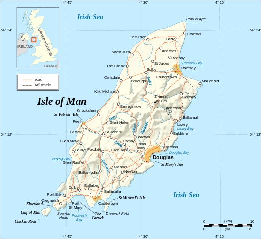
English: Map in English of the Isle of Man.
Note : The shaded relief is a raster image embedded in the SVG. Français : Carte en anglais de l'Île de Man. Note : Le relief ombré est une image bitmap incrustée dans le fichier SVG. UTM projection; WGS84 datum; shaded relief (composite image of N-W, W and N lightning positions); |
||
| Data | |||
| Šaltinis |
Own work ;
|
||
| Autorius | Eric Gaba (Sting - fr:Sting) | ||
| Leidimas (Šios rinkmenos panaudojimas kitur) |
|
||
| Kitos versijos |
[]
|


|
Šiame SVG faile yra išverstas įterptasis tekstas. Šį tekstą galite išversti ir į savo kalbą, naudodami SVG vertimo įrankį ar kitus SVG redaktorius. Daugiau informacijos rasite apsilankę: Apie SVG failų vertimą. |
Licencija
Aš, šio darbo autoriaus teisių savininkas, publikuoju jį su šiomis licencijomis:

|
Suteikiamas leidimas kopijuoti, platinti ir/ar redaguoti šį dokumentą pagal GNU Free Documentation licencijos versijos 1.2 ar bet kurios vėlesnės versijos sąlygas, publikuotas Free Software Foundation; be nekintamų dalių, be priekinių ir galinių tekstinių žymų viršeliuose. Šios licencijos kopija įtraukta dalyje, pavadintoje GNU Free Documentation License. |
| Šiam failui taikoma Creative Commons Attribution-Share Alike 3.0 Unported licencija. | ||
| ||
| Licencijos šablonas buvo priskirtas šiam failui kaip GFDL licencijos atnaujinimo dalis. |
Šiam failui taikomos Creative Commons Attribution-Share Alike 2.5 Generic, 2.0 Generic bei 1.0 Generic licencijos.
- Jūs galite:
- dalintis – kopijuoti, platinti bei persiųsti šį darbą
- pri(si)taikyti – adaptuoti darbą
- Su šiomis sąlygomis:
- autoriaus nurodymas – Turite pateikti atitinkamą kreditą, pateikti nuorodą į licenciją ir nurodyti, ar buvo atlikti pakeitimai. Tai galite padaryti bet kokiu būdu, bet ne taip, kad licencijos išdavėjas patvirtintų jus ar jūsų naudojimą.
- dalinkis panašiai – Jei perdirbsite, redaguosite ar atkursite šį darbą, jį galėsite platinti tik su tokia pačia ar panašia į šią licencija.
Galite pasirinkti, kurią licenciją norite naudoti.
Rinkmenos istorija
Paspauskite ant datos/laiko, kad pamatytumėte rinkmeną tokią, kokia ji buvo tuo metu.
| Data/Laikas | Miniatiūra | Matmenys | Naudotojas | Paaiškinimas | |
|---|---|---|---|---|---|
| dabartinis | 17:38, 4 rugsėjo 2008 | | 1 200 × 1 100 (686 KiB) | Sting | New standard colors |
| 02:03, 22 gegužės 2007 |  | 1 200 × 1 100 (786 KiB) | Sting | {{Information |Description=Map in English of the Isle of Man |Source=Own work ;<br/>Background map and shaded relief : [http://www2.jpl.nasa.gov/srtm NASA Shuttle Radar Topography Mission] (SRTM3 v.2) (public domain) edited with [http: |
Paveikslėlio naudojimas
Paveikslėlis yra naudojamas šiuose puslapiuose:
Visuotinis rinkmenos naudojimas
Ši rinkmena naudojama šiose viki svetainėse:
- Naudojama ca.wikipedia.org
- Naudojama cv.wikipedia.org
- Naudojama cy.wikipedia.org
- Naudojama de.wikipedia.org
- Naudojama en.wikipedia.org
- Naudojama en.wikibooks.org
- Naudojama en.wikisource.org
- Naudojama eo.wikipedia.org
- Naudojama es.wikipedia.org
- Naudojama es.wiktionary.org
- Naudojama fa.wikipedia.org
- Naudojama frr.wikipedia.org
- Naudojama gag.wikipedia.org
- Naudojama ga.wikipedia.org
- Naudojama gv.wikipedia.org
- Naudojama ha.wikipedia.org
- Naudojama hr.wikipedia.org
- Naudojama ja.wikipedia.org
- Naudojama kw.wikipedia.org
- Naudojama mi.wikipedia.org
- Naudojama mr.wikipedia.org
- Naudojama nl.wikipedia.org
- Naudojama sk.wikipedia.org
- Naudojama sl.wikipedia.org
- Naudojama stq.wikipedia.org
- Naudojama tr.wikipedia.org
- Naudojama tr.wiktionary.org
- Naudojama vi.wikipedia.org
- Naudojama vls.wikipedia.org
- Naudojama zh.wikipedia.org